Palestine under occupation

One place. Nine turning points.

As control
spread,
space narrowed.

Follow one fixed map. Red records the reach of Israeli state control and settlements; green shows the space outside that reach. Behind every change are Palestinian homes, journeys and lives.

01 / 09PALESTINIAN COMMUNITIES

1945

A land of towns, villages and families

About two in three residents of British Mandate Palestine in the mid-1940s were Palestinian Arabs.

The ≈⅔ figure is a share of people, not land. Green shows the Mandate area, not ownership or sovereignty.

Israel not yet establishedBritish Mandate areaREAD THE DATED LABELS

THE RECORD

Move through time

Drag to move through the record. Shapes between dates are animation, not reconstructed boundaries. ← → to step through.

Palestinian Arabs lived throughout Mandatory Palestine. The full map begins green to show the geographic frame, not exclusive ownership or sovereignty. The individual maps below document the land records in more detail.

Read the colours by date. The 1947 red shape is a proposal. The 1949 red shape is territorial control. Hatching marks occupation; later red in Area C marks administration, not sovereignty. Palestinians live in red and green areas alike.

The map is not the people. It cannot show every home lost, journey into exile or restriction on daily life. The dated facts and the maps below provide that evidence. Sources and method ↗

This site examines the policies and actions of Israeli governments and state authorities and their effects on Palestinians. It rejects antisemitism and collective blame of Jewish people or Israelis.

Who owned the land, and who came to control it?

These maps unpack the animated story. Start with the 1945 ownership records, then compare the 1947 proposal with the territory Israel controlled after the 1948 war. Every map uses the same frame and scale.

Sources for the comparison 1945 land records · 1947 UN partition proposal · UN history and refugee backgrounder.

c. 1900

Palestine under Ottoman rule
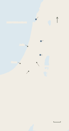
A locator map of late Ottoman Palestine. Squares mark the district centres of Acre, Nablus and Jerusalem. Dots mark other selected towns. Later borders are omitted.
  • Ottoman district centre
  • Other selected town

Site map using R. Huber / Library of Congress and PalQuest. Base Natural Earth.

The Ottoman Empire governed the region through several districts. Jerusalem was a separate district. Acre and Nablus belonged to the province of Beirut. [24] [25]
1923–46

The British Mandate

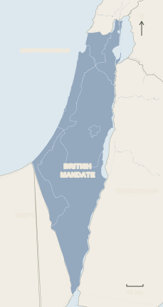
Blue-grey shows the territory under British administration west of the Jordan River. The Mandate came into force in 1923. Palestinian Arabs made up about two-thirds of the population by the mid-1940s. The map shows no individual land holdings.
  • British Mandate Palestine

Site map using Uri Farkash / Wikimedia Commons (adapted, CC BY-SA 4.0). Base Natural Earth.

British forces took control in 1917–18, and the League of Nations Mandate took effect in 1923. By the mid-1940s, Palestinian Arabs made up about two-thirds of the population. Land records distinguish Arab-owned, Jewish-owned and public or waste land. [26] [29] [1] [18]

1945 · Ownership

Arab and Jewish landholdings

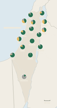
Sixteen pies show the shares recorded for the subdistricts. Arab holdings were the largest recorded category in most subdistricts. In Beersheba, ownership of most land was unresolved in the records. Each pie has the same size, and the map does not locate individual parcels. The Arab category includes a small amount recorded under other owners in the source. The full table is below the timeline.
  • Recorded Arab holdings*
  • Recorded Jewish holdings
  • Public or unresolved

Site map using UN land-ownership map and Village Statistics 1945, Table I. Base Natural Earth.

The circles sit near subdistrict centres and show each subdistrict’s shares. The Mandate records left title unresolved for most of Beersheba, including land used by Bedouin communities. [30] [31]

1947 · Proposal

The UN proposes partition

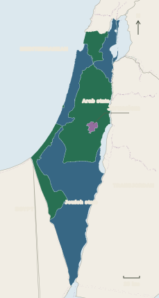
Green shows the proposed Arab state, blue the proposed Jewish state, and purple the proposed international zone around Jerusalem. The UN proposal was never implemented as drawn.
  • Proposed Arab state
  • Proposed Jewish state
  • Proposed international zone

Site map using UN partition plan and Uri Farkash / Wikimedia Commons (adapted, CC BY-SA 4.0). Base Natural Earth.

UN General Assembly Resolution 181 proposed separate Arab and Jewish states, allocating just over half the territory to the proposed Jewish state. It proposed international administration for Jerusalem. [2] [3]

1949 · Control

War and the Nakba

Jordan controlled the West Bank, including East Jerusalem. Egypt administered Gaza. The Green Line marked armistice lines.
  • Israel at the armistices
  • West Bank · Jordan
  • Gaza · Egypt

Site map using UN historical overview. Base Natural Earth.

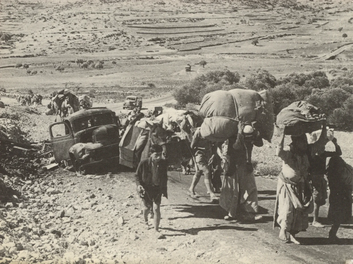
After the 1948 war, the State of Israel controlled about 77% of former Mandate Palestine. About 750,000 Palestinians fled or were expelled from their homes. [3] [4] [17]

1967

Israeli forces occupy the West Bank and Gaza

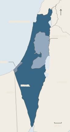
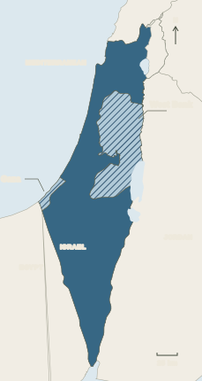
The map focuses on former Mandate Palestine. The stripes show the West Bank and Gaza under Israeli military occupation. The map leaves the Sinai Peninsula and Golan Heights outside the highlighted area.
  • Israel inside the Green Line
  • Occupied West Bank and Gaza

Site map using UN historical overview and ICJ case record. Base Natural Earth.

Israeli forces captured the West Bank, including East Jerusalem, and the Gaza Strip. The two territories went from separate Jordanian and Egyptian control to Israeli military occupation. [3] [6]

From 1995

Oslo divides the West Bank

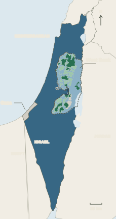
The map shows the zones as they developed after Oslo II. The Palestinian Authority took on civil affairs and internal security in Area A, and civil affairs in Area B, where Israel retained overriding security responsibility. The grey areas include special designations and Gaza, which this layer does not classify.
  • Area A · Palestinian civil and internal security
  • Area B · Palestinian civil administration, Israeli overriding security responsibility
  • Area C · Israeli civil and security control
  • East Jerusalem as defined by Israel
  • Israel inside the Green Line
  • Gaza and special zones
  • West Bank outline

Site map using UNICEF geographic layer. Base Natural Earth.

Palestinian civil administration was concentrated in separate areas. Israel retained near-exclusive control over Area C, which covers more than 60% of the West Bank. [19] [20]

December 2025

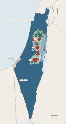
Movement restricted across the West Bank

Red circles show the number of movement obstacles per West Bank governorate over the same Oslo map. Circle size reflects the total, and circles do not mark individual obstacle locations. Gaza was outside the survey.
  • Obstacles by governorate
  • Same Oslo areas as the previous map
  • Area A · Palestinian civil and internal security
  • Area B · Palestinian civil administration, Israeli overriding security responsibility
  • Area C · Israeli civil and security control
  • East Jerusalem as defined by Israel
  • Israel inside the Green Line
  • Gaza and special zones
  • West Bank outline

Site map using UN OCHA access map and UNICEF geographic layer. Base Natural Earth.

The UN documented 925 movement obstacles in the West Bank, including East Jerusalem. Of these, 307 were checkpoints staffed continuously or intermittently. [7] [16]

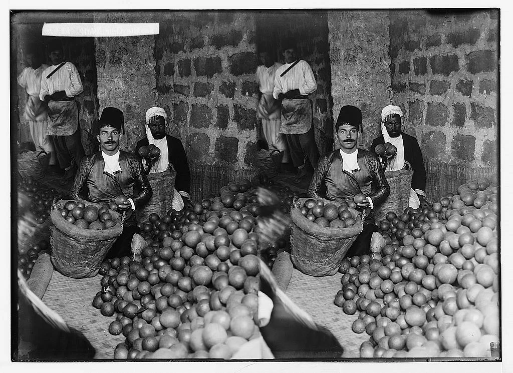
Two views of workers seated beside piles and baskets of oranges
Workers grading oranges in Jaffa, c. 1900–1920. The archive preserves this as a stereograph. American Colony Photo Department / Library of Congress. No known publication restrictions. Converted to WebP.
People carrying bundles follow pack animals down a track in Galilee
Palestinian refugees travelling from Galilee towards Lebanon, October or November 1948. Fred Csasznik / Wikimedia Commons · CC BY-SA 2.5.
View the 1945 ownership figures by subdistrict

Each percentage is a share of that subdistrict’s land. *Hadawi’s compilation includes 142,050 dunums held by other owners in its Arab column, about 0.54% of the total area. It also records unresolved title in Beersheba separately from public land. [30]

SubdistrictArab column*Jewish-ownedPublicUnresolved
Acre87.3%3.1%9.6%0.0%
Beersheba15.4%0.5%<0.1%84.1%
Beisan44.9%34.0%21.1%0.0%
Gaza75.7%4.4%19.8%0.0%
Haifa44.6%35.3%20.1%0.0%
Hebron95.7%0.3%4.1%0.0%
Jaffa52.9%38.6%8.5%0.0%
Jenin84.1%0.5%15.4%0.0%
Jerusalem88.4%2.1%9.5%0.0%
Nablus88.4%<0.1%11.6%0.0%
Nazareth52.9%27.6%19.5%0.0%
Ramallah99.4%<0.1%0.6%0.0%
Ramle78.8%14.0%7.1%0.0%
Safad70.5%17.5%12.0%0.0%
Tiberias52.6%38.0%9.5%0.0%
Tulkarm77.9%16.9%5.2%0.0%
All subdistricts48.5%5.7%5.7%40.2%
How to read the maps

The maps are generalised and use a common regional frame. The maps show proposals, administration, military control and movement restrictions. Palestinian communities also lived outside the green areas. The 1945 map shows recorded ownership shares rather than parcels. The later maps show proposed borders, control or restrictions. The 1945 ownership labels come from the historical records. The later maps use blue for the proposed Jewish state or for Israeli state control, separate from the amber used for recorded Jewish landholdings.

The British Mandate and 1947 partition maps adapt Uri Farkash’s partition map, recoloured and aligned approximately to the shared base. Those adaptations are licensed CC BY-SA 4.0. Base geography is from Natural Earth. Historical armistice and occupation outlines are generalised. The Golan Heights are outside the highlighted area.

The Oslo map uses the UNICEF geographic layer. It shows administrative designations, which do not capture every aspect of control on the ground. The West Bank obstacle circles use OCHA’s December 2025 survey and are positioned by governorate. See the UN access map for individual locations.

Go further back

The 1870s Survey of Western Palestine records towns, villages and terrain at about one inch to a mile. It complements the 1899 Ottoman administrative map, which shows the empire’s divisions.

Researchers used Ottoman tax registers from 1596 to reconstruct the locations of recorded villages and the districts to which they belonged. The records cover taxable settlements and households, with gaps. They can support a settlement map, with a different purpose from the boundary maps above.

View counts by governorate

Source UN OCHA’s December 2025 survey, published April 2026.

GovernorateObstacles
Bethlehem79
Hebron227
Jenin19
Jericho27
Jerusalem89
Nablus135
Qalqilya50
Ramallah183
Salfit53
Tubas34
Tulkarm29
Total925

Hear from Gaza and the West Bank

Follow Palestinian writers as they describe life in their own words.

Read the dispatches · Watch the documentaries

See how funding is checked

Read what we can verify about the appeals, or find a way to give your time.

Read the funding review · Find solidarity events in Australia

Palestinians are still losing their homes and access to land

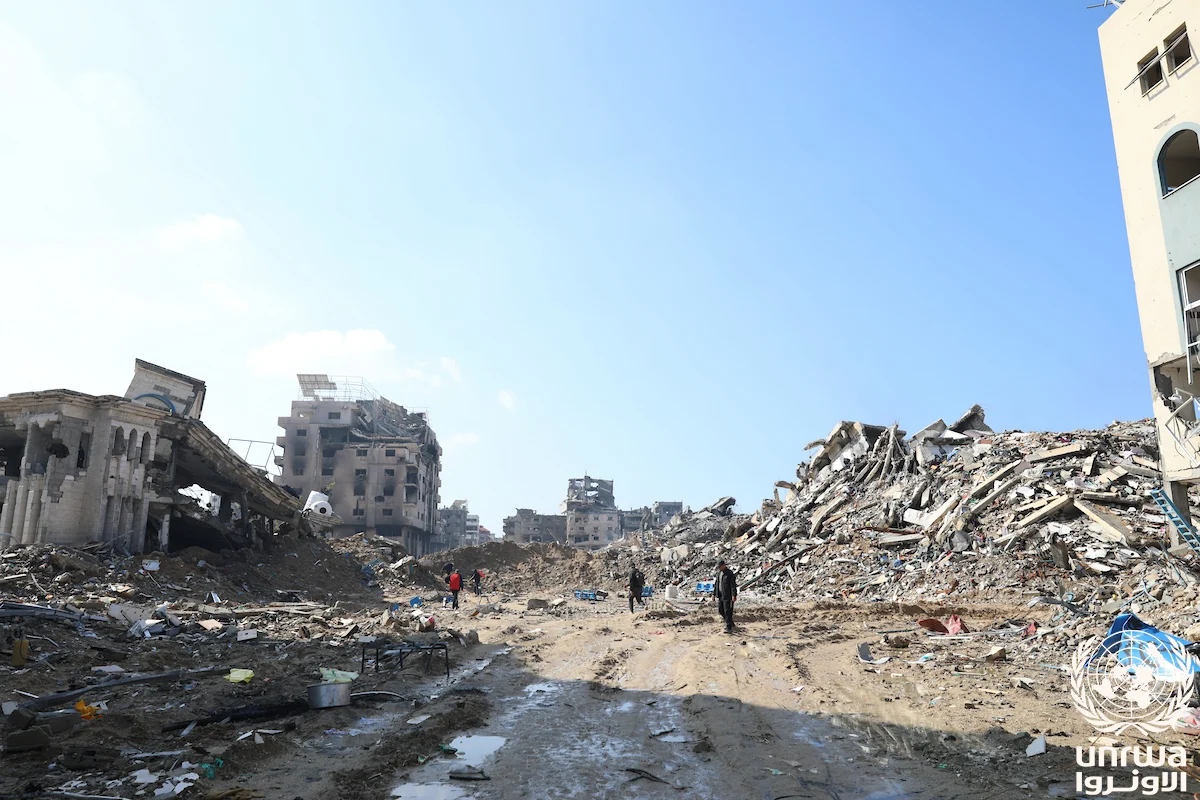
People walk down a muddy street between damaged buildings and piles of rubble in Al-Maqousi
Al-Maqousi, Gaza Strip, 3 February 2024. Abedallah Alhaj / UNRWA · Original photo record · CC BY-SA 3.0 IGO.

West Bank

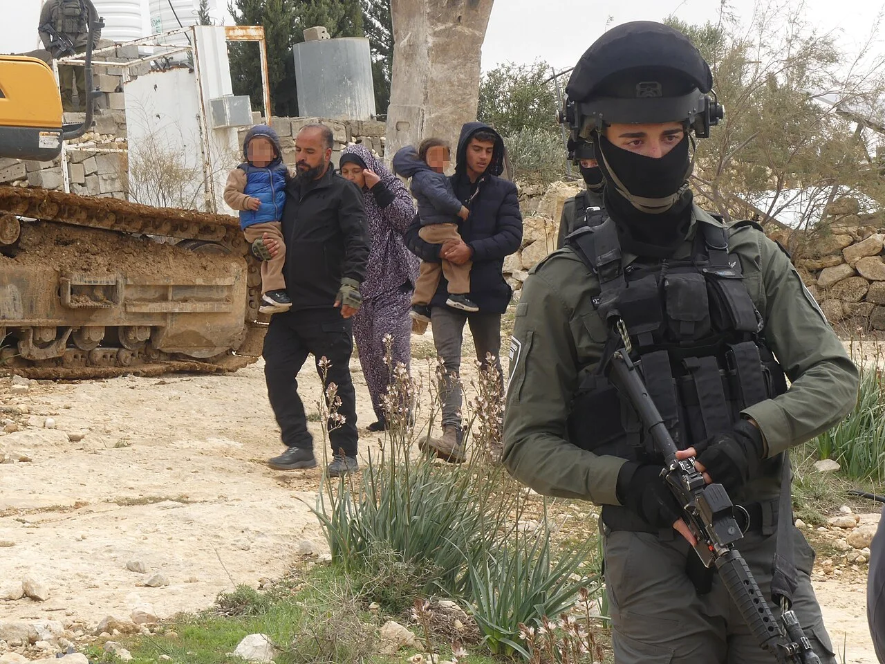
Palestinian adults carrying children past a demolition vehicle, with an armed Israeli officer in the foreground
A Palestinian family during the demolition of homes in Khallet Athaba’, West Bank, 10 February 2025. Mediterranea Saving Humans / Wikimedia Commons · UN OCHA incident record · CC0.

In its October 2026 update, UNICEF reported that demolitions, settler violence and related access restrictions had displaced an average of 17 Palestinians a day in the West Bank that year, including eight children. [21]

By early November, the UN had recorded 377 attacks by Israeli settlers connected to the olive harvest since the season started in September. Farmers faced assaults, theft and restrictions on reaching their land. [22]

Gaza

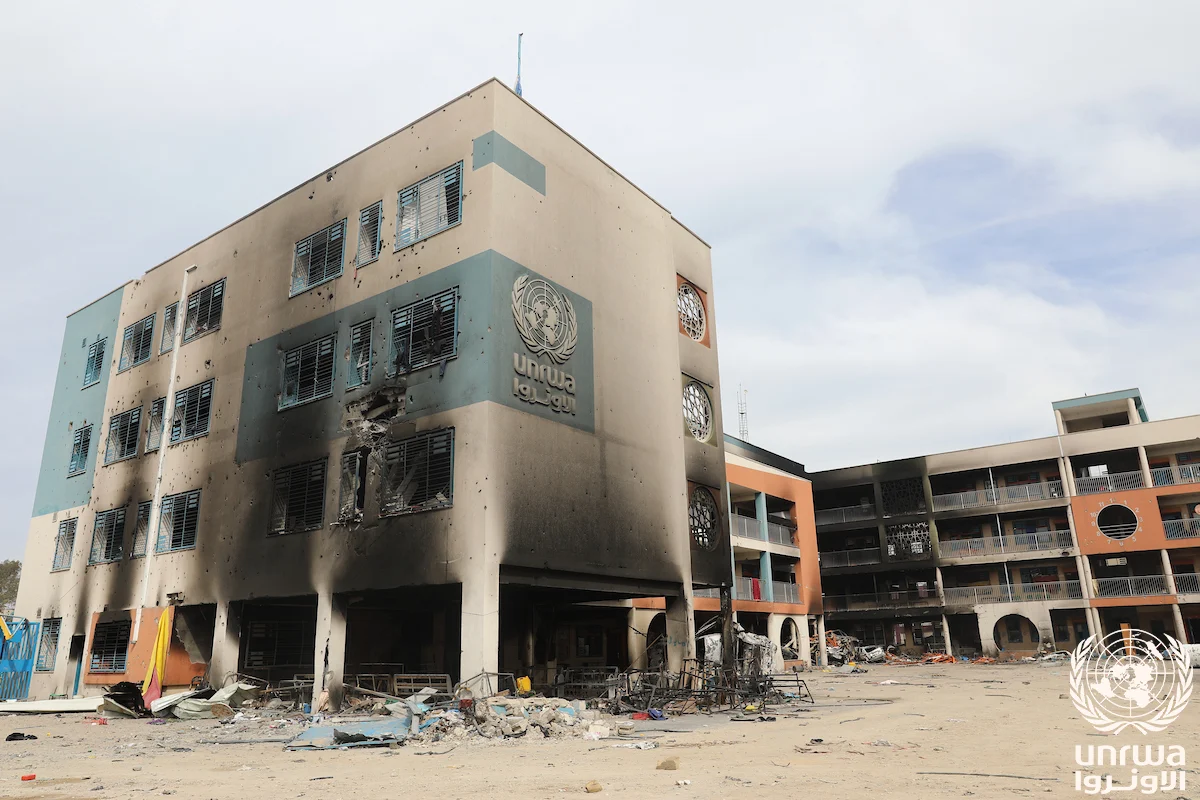
A school building with smoke-blackened walls, damaged windows and debris in the courtyard
UNRWA’s Remal co-ed school, Gaza Strip, 12 February 2024. Abedallah Alhaj / UNRWA · Original photo record · CC BY-SA 3.0 IGO. Full frame.

The Israeli government evacuated Israeli settlements and withdrew permanent ground forces from Gaza in 2005. The International Court of Justice said Israel continued to exercise key elements of authority and that its obligations under occupation law corresponded to its degree of effective control. [6]

In early November 2026, the UN reported that airstrikes, shooting and shelling by Israeli forces continued to hit populated areas in Gaza. Gunfire damaged tents at a displacement site in northern Rafah and forced an aid organisation working on flood protection to leave. [22] [23]

What this means in Australia

Australia formally recognised the State of Palestine on 21 September 2025. The ICJ’s 2024 occupation opinion says states must refrain from recognising as lawful the situation arising from Israel’s unlawful presence in the occupied territory or helping maintain it. [6] [13]

A question for your federal MP
What steps is Australia taking to support Palestinian self-determination and to distinguish between Israel and the occupied territory in its dealings?

Use the AEC’s postcode or suburb search to find your electorate and the name of your federal MP. If you write, include a question you’d like them to answer in their own words.

Palestinians in Australia

Randa Abdel-Fattah speaks into a microphone at a lectern
Randa Abdel-Fattah speaking at an event in Melbourne, April 2026. Matt Hrkac Photography · Original photo record · CC BY 4.0. Photographer’s published crop.

Meet the people making films, writing books, teaching family recipes, bringing Arabic music to the stage and finding new ways to test medicines.

Meet five people through their work

Palestinian goods in Australia

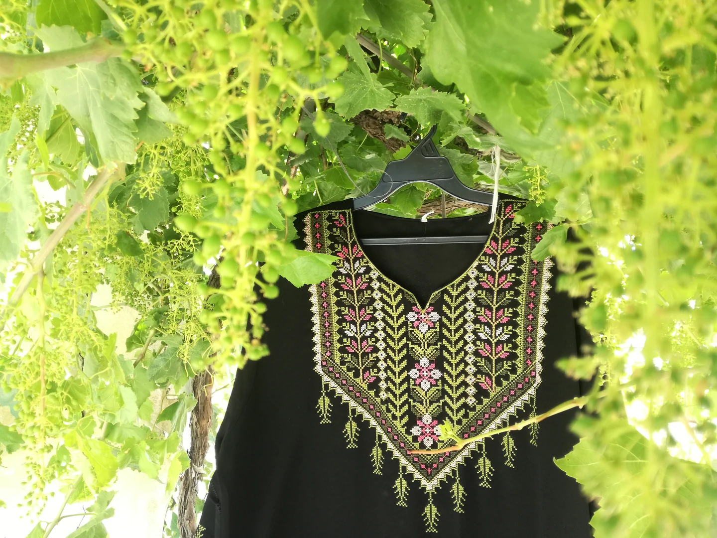
Red, green and gold embroidery on a black Palestinian dress hanging among leaves
Hand-embroidered Palestinian dress, photographed in 2020. Read UNESCO’s entry on the tradition. Aseel zm / Wikimedia Commons · CC BY-SA 4.0.

See what Australian sellers disclose about their Palestinian suppliers and how purchase money is used.

Read the purchase review

Read the evidence

Numbered references lead to the evidence for the text and figures. Photos carry their own credits and dates. Maps identify their base geography and the records used to draw them.

  1. Mandate-era land records, 1945 (UN, pp. 43–44)
  2. UN partition plan and original map, 1947
  3. UN history of the question of Palestine
  4. UN Resolution 194, paragraph 11
  5. ICJ opinion on the barrier, 2004
  6. ICJ opinion on the occupation, 2024 (§§ 223–229, 285)
  7. UN OCHA OPT access map, December 2025
  8. Rome Statute, Article 7
  9. Human Rights Watch, 2021
  10. Amnesty International, 2022
  11. B’Tselem, 2021
  12. ICJ case record, South Africa v Israel
  13. Australia’s recognition of Palestine, 2025
  14. Reuters on Israel’s response to the ICJ opinion
  15. Israel’s Basic Laws, including the Knesset and Nation-State laws
  16. UN OCHA OPT access factsheet, April 2026
  17. UN backgrounder on Palestinian refugees
  18. UN Special Committee on Palestine, 1947 population figures
  19. UN OCHA on Area C and the Oslo division
  20. UNICEF GIS layer for the Oslo areas
  21. UNICEF West Bank situation update, October 2026
  22. UN OCHA humanitarian situation report, 5 November 2026
  23. UN OCHA Gaza impact snapshot, 4 November 2026
  24. R. Huber’s Ottoman administrative map, 1899 (Library of Congress)
  25. Ottoman territorial reorganisation, 1840–1917 (PalQuest)
  26. League of Nations record on the Mandate taking effect, 1923
  27. Survey of Western Palestine, fieldwork in the 1870s (Open Jerusalem)
  28. Ottoman tax registers of 1596 and their use in historical geography (PalQuest)
  29. Political history of Palestine under British administration (UN archival document)
  30. Village Statistics 1945, Sami Hadawi compilation, Table I (pp. 37–39)
  31. UN map of land ownership by subdistrict, based on 1945 data
  32. Israel’s Absentees’ Property Law, 1950 (law text)
  33. Adalah on how Israel’s Absentees’ Property Law was used
  34. UN study on land acquisition and Israel’s 1953 Land Acquisition Law
  35. UN OCHA GIS inventory of settlements and outposts, extracted 9 November 2026
  36. UN OCHA on Gaza after the 2005 withdrawal and OCHA on the blockade from 2007
  37. Peace Now settlement summary for 2025 and June 2026 state land report
  38. UN OCHA humanitarian report, 15 October 2026
  39. UN, First Emergency Force background on Gaza in 1956–57